$1.4 Trillion Wildfire Threat Hiding in U.S. Neighborhoods
Claire O’Connor had a hard time believing her Pacific Palisades, CA, home carried any real wildfire risk—even after her insurance policy was dropped in November 2024.
“I mean, as if our house is going to burn down,” the Los Angeles real estate agent recalled telling her husband at the time. “So many houses would have to burn to get to our house.”
The house wasn’t in an isolated, rural area. Nor was it pressed up against a forest. It was in a traditional suburban neighborhood, surrounded by other homes.
“We were pretty far from the hills,” she told Realtor.com® last year. “There was, like, rows and rows of houses before us.”
Then, just two months later, the unthinkable happened. O’Connor lost her home in the Palisades fire, one of more than 4,700 homes partly or entirely destroyed.
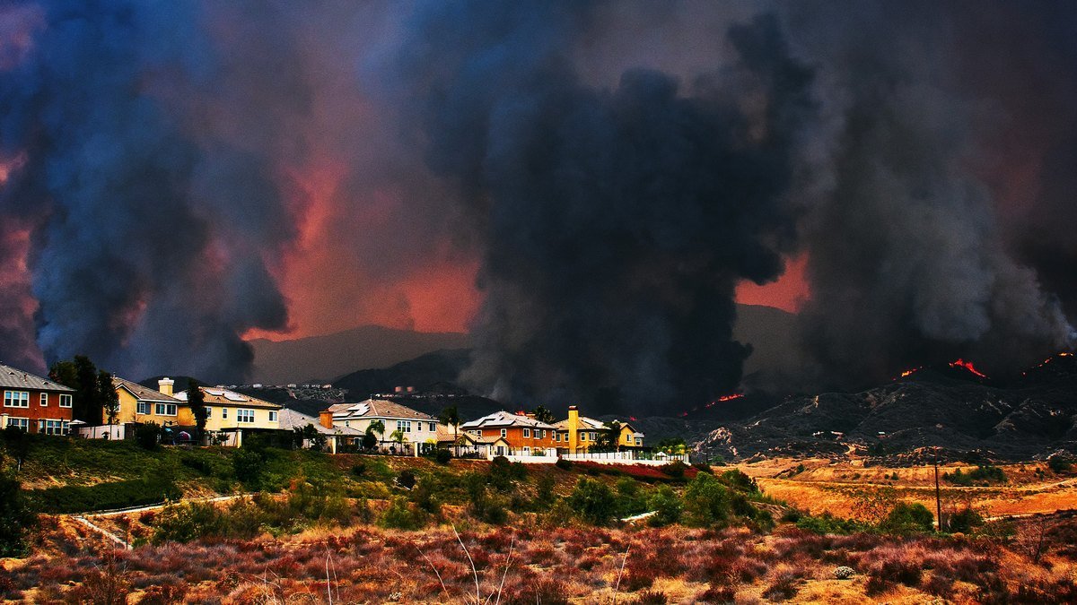
O’Connor is far from alone in assuming that neighborhoods offer some insulation from wildfire risk. But a new report from Cotality suggests that assumption can obscure a major source of danger: Once fire reaches a developed area, it can spread from structure to structure.
Across the 10 states with the greatest number of properties facing moderate or greater wildfire risk, more than 2.5 million properties meet that threshold, according to Cotality’s 2026 Wildfire Risk Report. Together, those properties have a combined reconstruction cost value approaching $1.4 trillion.
Wildfire risk doesn’t stop where the forest ends
Traditional wildfire models generally concentrate risk where natural fuels are dense and terrain is steep, then step that risk down as development becomes denser, according to Cotality.
But that logic can break down once a fire reaches a neighborhood.
Ryan Handy, a wildfire and land use expert and program manager for Headwaters Economics’ Community Planning Assistance for Wildfire program, explained it simply.
“Homes are fuel for fire,” Handy told Realtor.com last week. “They spread wildfire through communities—in some cases, much more effectively than trees do.”
Unlike the wall of flames people might imagine approaching a home, wind can carry burning material miles ahead of the main fire, Handy explained. Those embers can land on flammable surfaces like a roof, deck, woodpile, or even porch furniture—ignighting the structure before the perimeter of a fire ever reaches its front door.
“Homes themselves are very, very flammable,” Handy said.
That helps explain the seemingly paradoxical images left behind by some major fires: entire neighborhoods reduced to foundations while trees remain standing.
Cotality attempted to quantify how much that structure-to-structure danger can change a property’s risk.
In a parcel-level analysis, Cotality rated wildfire risk property by property, assigning each parcel a score based on the level of wildfire danger it faces. A score of 51 or higher was considered moderate or greater risk.
When Cotality added conflagration potential—the danger of fire spreading from structure to structure—it found that some properties’ scores could rise by as many as 40 points.
A jump that large was enough to push meaningful wildfire risk deeper into neighborhoods that legacy assessments could classify as relatively low risk—and the scale of that hidden exposure becomes especially striking in major metropolitan areas.
California contains 6 of the 10 metro areas with the largest number of properties at moderate or greater risk, according to Cotality. Los Angeles leads the country, with nearly 250,000 properties carrying more than $209 billion in reconstruction cost value. It’s followed by Riverside and San Diego, while Sacramento ranks fifth, San Francisco sixth, and Oxnard ninth.
Austin, TX, ranks fourth overall and has the largest concentration of exposed properties outside California, with more than 100,000 properties representing $49.2 billion in reconstruction cost value.
Handy’s own research has reached a similar conclusion about the geography of the threat.
Headwaters identified roughly 1,100 U.S. communities facing heightened urban conflagration risk, including neighborhoods along the Gulf Coast, in the Southeast, East Texas, and Oklahoma.
“Wildfire risk is much more pervasive than flood risk,” Handy said. “It exists everywhere. It exists in places that people don’t even think about.”
A fire-resistant home can still be vulnerable to the house next door
That changes not only how homeowners should think about where wildfire risk exists, but also what it takes to reduce it.
Home hardening still matters enormously. In an analysis of 6.8 million single-family residences, Cotality found that homes in the top 10% for mitigation had expected losses roughly 78% below the statewide average, while homes in the bottom 10% had expected losses more than 10 times the average.
The company gives particular weight to measures, including maintaining a zero-to-5-foot noncombustible zone around a home’s foundation and having a verified Class A roof.
But both Cotality and Handy point to the same limitation: A homeowner can’t fully solve a neighborhood-scale fire problem on a single parcel.
“Unlike flooding risk, wildfire is really a community-scale problem,” Handy said. “How the home next to you is constructed can affect if your home burns down or not.”
That’s because a neighboring home that catches fire can expose the houses around it to radiant heat and flames—or generate embers that ignite structures even farther away.
“We have to be thinking of a broad neighborhood because my home, once it ignites on fire, can burn the homes across the street down,” Handy said. “It can burn homes technically miles away if the embers are blowing in the right direction.”
For Handy, that makes building codes, landscaping requirements, and other communitywide land-use policies an essential part of wildfire resilience—not merely the decisions made by individual homeowners.
When evaluating a community, she recommends looking at its wildfire risk as well as whether local officials recognize that risk and have adopted building and land use standards designed to address it.
The other risk homeowners may be underestimating is financial.
Cotality warns of a widening “protection gap” between what a home is insured for and what it can actually cost to rebuild after a disaster.
Years of construction inflation can leave policy limits lagging actual replacement costs, while a postdisaster surge in demand for contractors, labor, and materials can push rebuilding costs even higher.
Again, O’Connor’s experience offers stark proof.
After her insurer dropped her, she obtained coverage through the California FAIR Plan supplemented by a wraparound policy. It cost significantly more, she said, but left her insured when the fire came.
Even so, coverage has not absorbed all of the costs of displacement. O’Connor and her family moved into an expensive rental after losing their home, and she said insurance is covering only about half of the lease.
That’s why she now advises her clients to priortizie the policy that fits their needs, not necessarily the cheapest one.
“Definitely pay for the right insurance,” she says.
For a homeowner, then, the lesson of the $1.4 trillion in exposed property isn’t just to look more carefully at how close a house sits to trees or brush. It’s to look at the houses around it, too.
The rows of homes O’Connor once saw as a buffer from wildfire were evidence of just how far the flames would have to travel to reach her.
What she didn’t know was that, under the wrong conditions, those homes could speed the fire there.